The Spray Field: Stockton's First Environmental Initiative
By Dr. Claude Epstein, Professor Emeritus, Environmental Studies
Stockton has long been known as the “Environmental College.” Early meetings of the college’s first Board of Trustees stressed an environmental focus as part of the college’s development and this focus was declared in 1970 in the first prospectus.1 Soon, Stockton was commonly described as the “Environmental College” by Jersey academics, politicians, bureaucrats, and the local population. Stockton was conceived of, constructed, and developed during the peak of the environmental movement of the late 1960s and 1970s and was part of the state’s response to this movement.
Stockton’s campus was purchased, planned, and under construction in 1970. The college buildings were well underway but the campus could not open until it settled its utility needs. In particular, the college needed a means of sewage treatment and disposal since there was no regional sewer line nearby. The engineering consultant for the college suggested an onsite treatment plant to handle the wastewater from the dormitories and school buildings,2 with an accompanying effluent spray irrigation facility to further cleanse the resulting sewage.3 The entire facility was given provisional approval by the New Jersey Department of Environmental Protection, providing that Stockton cease its operation and tie into the regional sewage system once it reached the college.
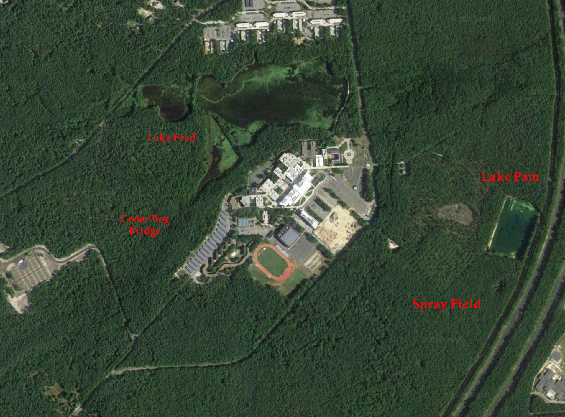
Figure 1. A recent satellite photograph of the Stockton Campus. Lake Pam, with the Spray Field adjacent (see the grid pattern that remains in the forest), are to the east (right), near the Garden State Parkway.
The Sewage Treatment Plant
Sewage was pumped from the buildings to the treatment plant where it was first aerated. Then the liquid portion, called effluent, was separated from the solid portion, called septage, by means of bacteria breaking it down and by gravitational settling. The effluent was then chlorinated to kill the remaining bacteria and other microorganisms. The chlorinated effluent was then stored in a holding tank. Once approximately 1300 cubic feet of effluent accumulated, it was pumped through a 6" main out to the spray field (Figure 2).


The Spray Field: “The Living Filter”
The spray field originally consisted of nine 5" aluminum “lateral” irrigation pipes set perpendicular to the main pipe, every 60 feet. (Three of the laterals would be used per day and rotated daily.) Sixteen spray nozzles were set two feet above ground level, attached to each lateral. The nozzles and laterals were standard agricultural irrigation fixtures. The chlorinated effluent would be sprayed through these nozzles in a 30' radius into the surrounding woodlands. Branches and shrubs that interfered with the radial spray were removed to optimize the area of spray. The original spray field occupied approximately 7.5 acres.
The spray field utilized the concept of the forest’s “living filter.” The effluent spray was spread over the ground cover vegetation, forest floor litter, and topsoil. Much of the spray would either evaporate off of the plant and soil surfaces or be absorbed through plant roots for growth and respiration and then be transpired into the atmosphere. Moreover, films of sprayed effluent would be held on soil grain surfaces by capillary forces and then evaporated or absorbed later by vegetation. The ecological advantage of the “living filter” is that plants would receive water, albeit effluent, daily, which was also enriched in nutrients. Consequently, forest productivity would be augmented. By so doing, the vegetation and soil surfaces would partially purify the sprayed effluent. Effluent ultimately reaching the underlying water table would thus be rejuvenated. Potentially, a good idea.
Passing the Torch
Concern for preservation of the environment has been present over the last one hundred and fifty years or so. By the start of the twentieth century, national parks and wildlife conservation regulations were well underway, and government agencies were established to oversee these initiatives. During the 1930s, the Roosevelt administration developed many environmentally based initiatives. The Civilian Conservation Corps (CCC), the Works Progress Administration (WPA), the Soil Conservation Service (SCS), and other agencies provided employment for many Americans, working to improve the environment. This developing environmental awareness proved a boon to Stockton.
During the late 1960s through early 1970s, as Stockton was being planned, several important natural scientists, whose careers began in the 1930s, lent their support to the development of the campus. One idea they passed along was the effluent spray field, an “innovative,” though largely untested form of sewage treatment. Its potential impact on the surrounding environment was unknown. Silas Little of the U.S. Forest Service helped guide the college in this matter. He was well known for his work dealing with fire as an agent of Pine Barrens ecological succession, prescribed burning as a means to control the intensity of forest fires, pine tree hybridization, and even the impact of spray irrigation on the environment. He acquired a three-year grant from the U.S. Forest Service so that the college faculty and students could study the spray field’s environmental impact.4 Little had other local scientists provide additional scientific insight in terms of research design and possible outcomes. These scientists included Gordon Meisler and William Kam from the U.S. Geological Survey, George Pierson of the New Jersey Forest Service, and Thornton Hole of the Natural Resource Conservation Service.
The spray field study, as it was known, served as an independent study in the field for Environmental Studies students from 1971 to 1975. Eight members of the faculty and thirty-two students undertook research on the spray field.5
Human Mismanagement of a Good Idea
Sewage treatment is, perhaps, as agreeable a topic for conversation as cold sores. No one really wants to know about it; nevertheless, it cannot be ignored. Stockton could not have opened its campus without some means of sewage disposal. If the county sewage system had reached the college, this would not have been a concern, but the campus was not scheduled to join the sewage system until 1974 or 1975 (in fact, the tie-in did not occur until 1982!).
Several entities were involved in decisions about campus sewage treatment: Stockton’s Office of Campus Planning; college architects Geddes, Brecher, Qualls, and Cunningham; college engineers Jackson and Moreland; ecological consultants Jack McCormick and Associates; spray field consultant Earl A. Myers; the U.S. Soil Conservation Service; and the construction firm that actually built the treatment plant and effluent spray irrigation field. That is a lot of cooks to make one soup. Problems were not long in coming.
1) Spray Field Location
All parties seemed to agree that the upland forest was the most suitable location for the effluent spray field since its soil was permeable and its water table well below the surface (Figure 3). This location optimizes the water holding capacity of the soil above the water table as well as the degree of effluent purification (i.e. rejuvenation). Jackson and Moreland, the engineers responsible for designing the sewage treatment system, located two sites (Figure 3)—one for immediate use and a second for expansion—both were on the requisite uplands.6 The Soil Conservation Service examined the first site and found approximately a third of the spray field on pitch pine lowlands with water tables too close to the surface.7 Geddes, Brecher, Qualls, and Cunningham, the college architects, authorized Jackson and Moreland, the college engineers, to abandon the first three laterals and add three new laterals to the original site and this was done.
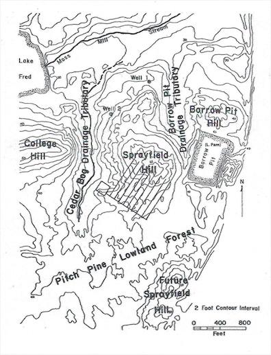
Figure 3. Map of Spray Field and adjacent Topography
2) Spray Field Site Construction
Jack McCormick and Associates recommended a more audacious spray field plan. Their calculations led them to believe that the spray field ought to occupy 70 acres.8 They later revised this to an increased 75 acres.9 The spray field as built was only 7.5 acres, which was later expanded to 13 acres—still not even one fifth of Jack McCormick and Associates’ plan. They wanted the lateral irrigation pipes to be made of plastic and buried to make them less conspicuous, as well as low trajectory spray nozzles to avoid significant vegetation destruction during winter operations and minimal impact on the vegetation within the radius of spray. This was to be achieved by the hand removal of branches or small trees that interfered with the spray’s distribution. All the other entities were in agreement about spray nozzle trajectory, but McCormick and Associates’ other suggestions were ignored.
Jackson and Moreland’s spray field consisted of aluminum irrigation pipe set on low pedestals above the ground and graded to drain back to the treatment plant holding tank once spraying was finished. This would avoid effluent freezing within the pipes and nozzles in winter. Earl Myers, Jackson and Moreland’s spray field consultant, recommended bulldozing a ten-foot diameter with the nozzle in its center. But Jackson and Moreland misread Myers specifications, bulldozing a ten-foot radius on both sides of the nozzle. Now the nozzles sprayed their effluent over twenty feet of deforested ground instead of ten. Jackson and Moreland claimed the topsoil was still present and would still serve as the “living filter.” As it turned out, much of the topsoil had been removed, leaving exposed sand to receive the effluent.
3) Spray Field Operation
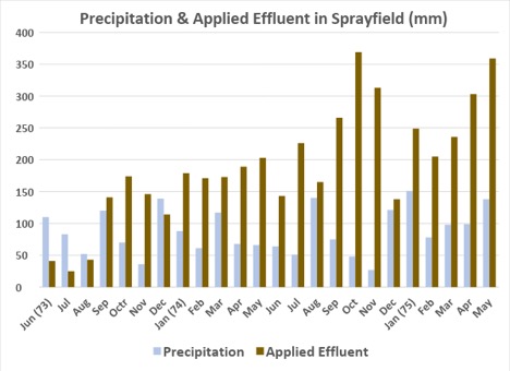
Both McCormick and Associates and Jackson and Moreland suggested a weekly spray dosage rate of no more than 2 inches (50.8 mm) per acre. This seems to be based on the permeability of the Downer sandy loam, rated as well drained. But the difference in spray field size is curious. Why McCormack and Associates wanted a 75 acre spray field while Jackson and Moreland only need 7.5 acres is not clear from the documents. One can see that the smaller spray field would become a far wetter place. In one sense, every day was a rainy day in the spray field. By 1974, the effluent application often exceeded natural rainfall by a factor of two (Figure 4).
View Figure 4
Precipitation & Applied Effluent in Sprayfield
Excessive effluent dosage of the spray field occurred from 1972 through 1981. Part of this problem arose based on the assumption that the treatment plant and spray field would operate for only two years and after this point the college would tie into the county sewage disposal system. However, that did not happen until 1982, leaving the spray fields operative for 10 years. By then the college population exceeded the spray field’s designed capacity. Three additional laterals were added north of the spray field but this did not solve the excessive effluent dosage.
View Capacity Exceedance
Spray Field Capacity Exceedance

Effluent surface ponding soon became a problem, causing the Atlantic County Mosquito Commission to issue Stockton a citation for this mosquito hazard.10 In response, the treatment plant operator, Bart Presti, cleverly moved the lateral pipes into the woodlands left between the deforested laterals, generally solving the mosquito problem.
Another operational problem was the lack of long-term winter effluent storage. The college’s consultants felt that the treatment plant and spray field could operate all year.11 Myers, the spray field consultant, believed that, based on his experience at the facility at Penn State, the spray field could continue operation through most of the winter as the temperature would not remain cold for long. But during winter operations effluent froze on the ground and on the lower portions of trees and shrubs (Figure 5). This eventually led to the loss of most of the pine trees in the spray field.


Environmental Impact of Stockton Spray Field
1) Water Table Rise and Mounding
The spray field was situated on the south side of “Sprayfield Hill” and was surrounded by three lowlands—the Cedar Bog Drainage Tributary to the west, the Borrow Pit Drainage Tributary to the east, and an extensive Pitch Pine Lowland Forest to the south (Figure 3). Groundwater on the underlying water table would flow toward these three lowlands resulting in the formation of a gentle asymmetrical mound with a steeper northeast slope.
The daily application of effluent amplified the mound so that it rose more in the center than along its margins. Water levels were taken monthly and water table maps constructed.12 Under natural conditions, the entire water table rose from late summer to early spring and sank from late spring to early fall. However, effluent application augmented water table rise within the spray field and formed a higher mound. The groundwater moved more rapidly to the northeast and northwest but quite sluggishly to the south. In addition, the application of effluent raised much of the water table too close to the surface, thereby rendering the “living filter” far less effective.
2) Changes in Vegetation
The vegetation in the spray field changed radically after the construction and operation of the spray field.13 Native trees and ground cover were removed and soon replaced by invasive grasses, sedges, and herbaceous plants (Figure 6). Many of these replacements were more characteristic of lake shores rather than forested uplands.
The trees of the original and surrounding woodland consisted of pitch pine (Pinus rigida) and several oak species (Quercus spp.); the ground cover consisted of bracken (Pteridium aqulinum), sheep laurel (Kalmia angustifolia), wintergreen (Gaultheria procumbens), black huckleberry (Gaylussacia baccata), blue huckleberry (Gaylussacia frondosa), and low blueberry (Vaccinium vacillans). The invasive replacements included broom sedge (Andropogon virginicus), crab grass (Digitaria sp.), panic grass (Panicum sp.), sedges (Carex spp.), club rush (Scirpus rubricosus), and the common rush (Juncus effuses), and the flowering plants included pokeweed (Phytolacca americana), lance-leaved violet (Viola lanceolata), black nightshade (Solanum nigrum), goldenrod (Solidago tenuifolia), and white fireweed (Erechtites hieracifolia)
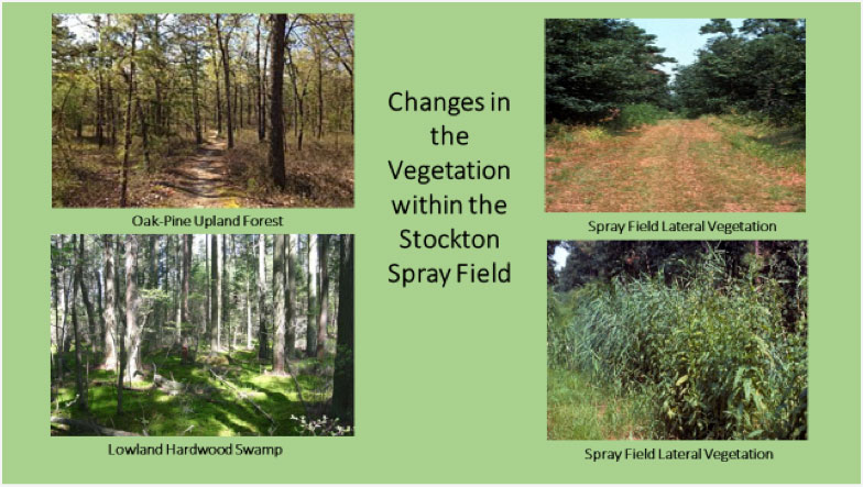
Figure 6. Woodlands surrounding spray field (left) and invasive plants within spray field (right)
3) Impact on Surface Water and Groundwater Quality
The spray field had the natural capacity to absorb, hold, and chemically rejuvenate the effluent applied to it daily. But there was a limit to the volume of water and chemicals it could absorb. The volume of water applied soon overwhelmed the absorptive capacity of the natural environment.
The underlying water table for much of the spray field was too close to the surface. Even before the first effluent was applied, much of the spray field water table was less than four feet from the surface; the depth from surface to water should have exceeded that measurement. But once the effluent was applied, the water table mound grew and expanded until the spray field came far too close to the surface. Ponded effluent began to accumulate in the lower elevations of the spray field and beyond.
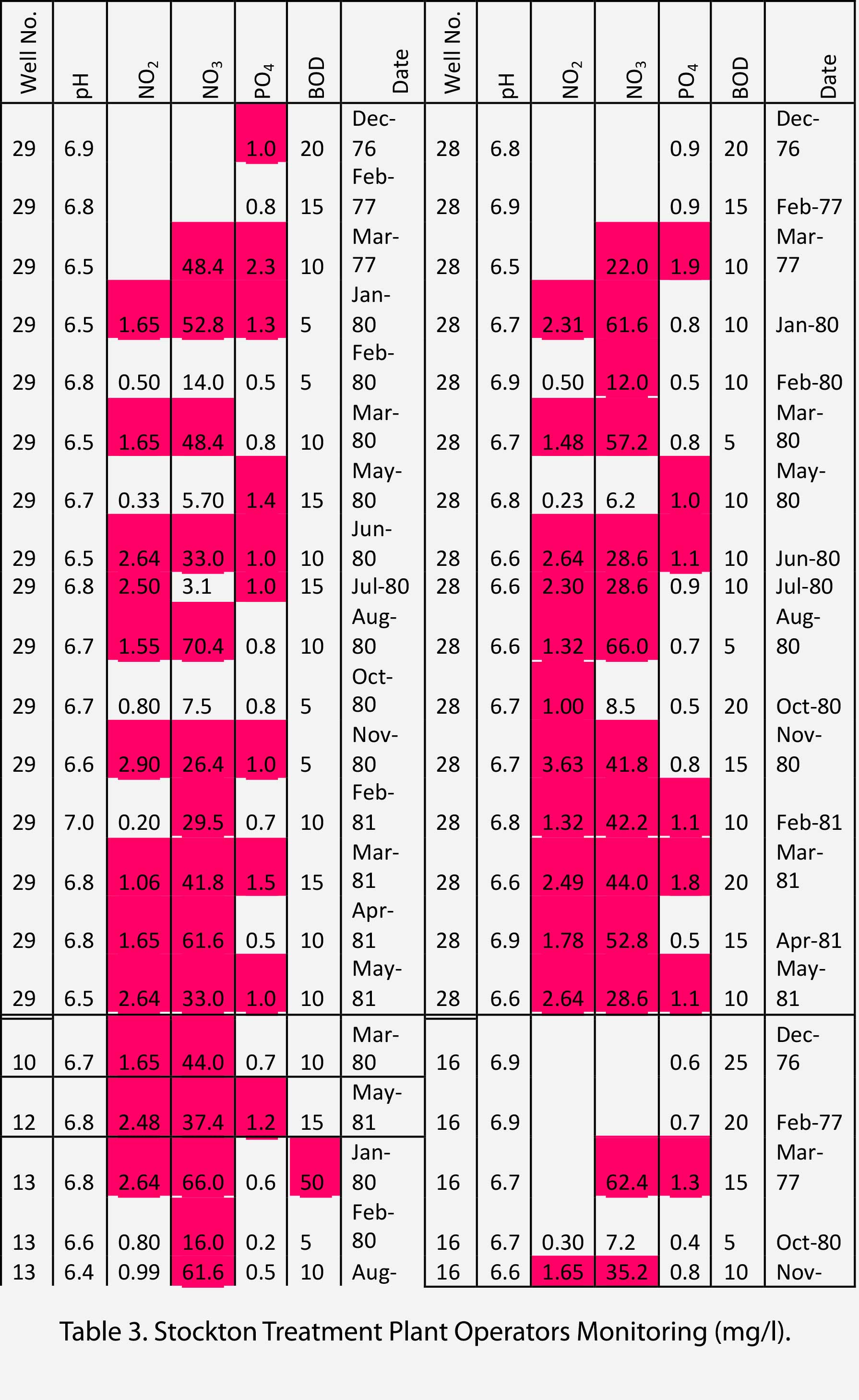
The treatment plant operators monitored the water table water quality from nine wells within the spray field on a monthly basis and reported to the New Jersey Department of Environmental Protection.14 The effluent, even after secondary treatment, was far more enriched in dissolved chemical compounds than the surrounding groundwater and surface water (Table 3). Nitrogen and phosphorus compounds were monitored specifically because of their negative impact on surface water environments such as Lake Pam, the drainage ditch, and even Moss Mill Stream. Ground water, taken from beneath the spray field, exceeded the potable water maximum much of the time. This became a violation once the Clean Water Act took effect.
View Table 3
Table 3
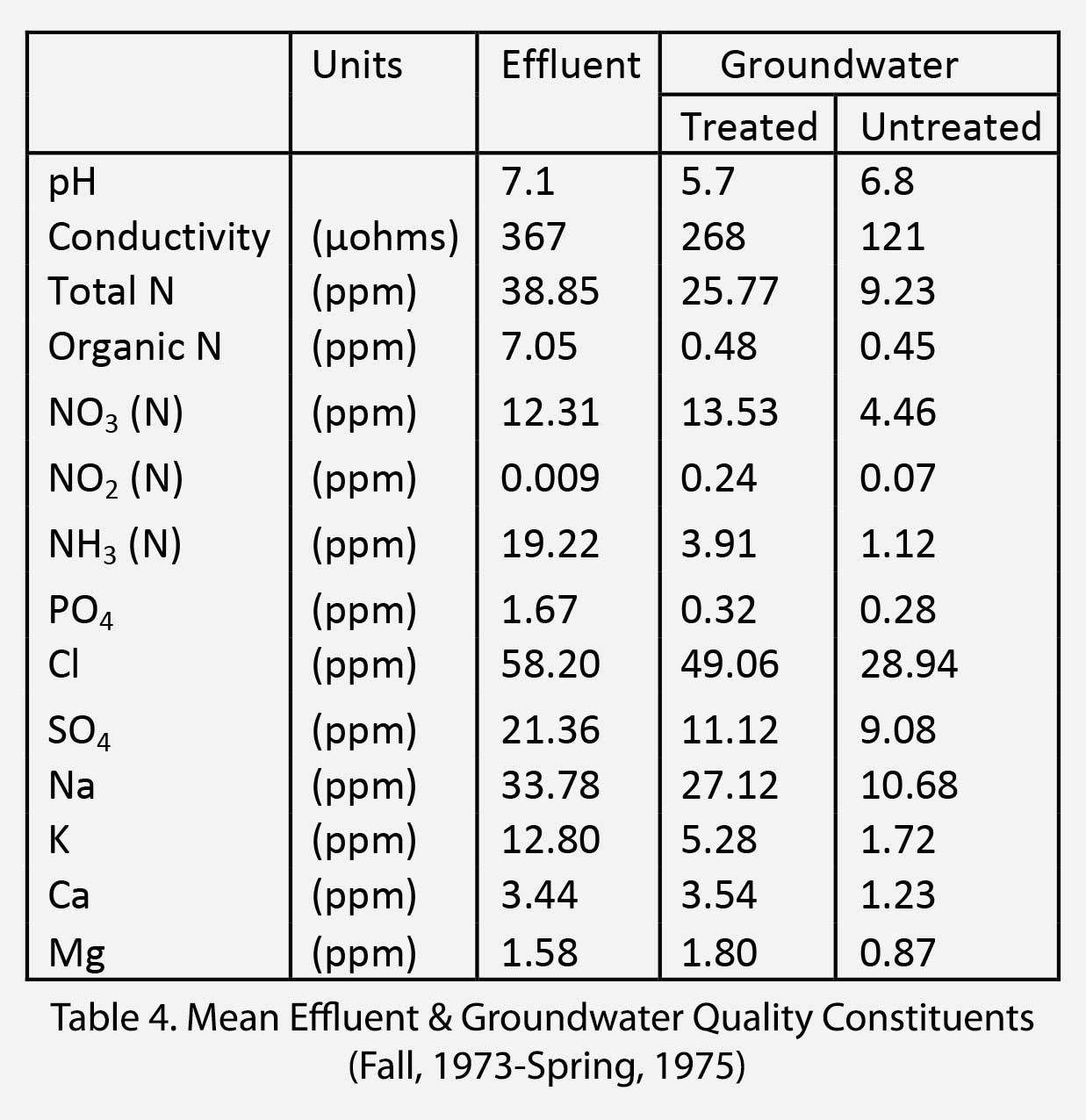
Gary Sawhill undertook more detailed water quality monitoring, using the water quality laboratory at Rutgers University.15 He examined more water quality parameters from wells in and around the spray field. “Treated” wells were within the spray field while “Untreated” wells lay just outside the spray field. Groundwater from within the spray field was rejuvenated in all monitored components except for nitrate, nitrite, calcium and magnesium, but the groundwater within the spray field was enriched in all components (Table 4). Nitrate in particular seemed to accumulate in concentrations even greater than that in the effluent. This posed an environmental threat.
View Table 4
Table 4
Adventures in the Spray Field: Splendor (?) in the Grass
In addition to its role in sewage management, the spray field fostered many different kinds of activities in its time. The first involved the scientific monitoring of the water table. Twenty-one galvanized pipes with well points were pounded into the ground to penetrate the water table beneath: a small hole was dug into which a one-inch diameter pipe and well point were set. Next teams of students pounded the pipe and well point into the ground using a hundred and twenty-five pound elevator weight. These teams took turns, relieving one another in the strenuous burden of pounding pipes up to twenty feet into the ground. An élan developed among these students over the weeks. They named themselves the “Sprayfield Spiggots” and had tee-shirts made with the group name on the front. An appropriate, though vulgar, sewage treatment workers’ slogan (i.e., it may be “#@$&” to you but it’s my bread and butter) was translated into Latin to avoid offense, and placed on the back. This subterfuge was only partially successful. No one ever commented or asked for a translation; however, the Classics Professor took offense. Once the last pipe was emplaced, the group held a champagne party in the spray field to commemorate their achievement.
The spray field, described poetically, was set in a sylvan glade. Since surrounding forest was watered with enriched effluent several times a day, the forest grew lush and verdant. The cleared laterals were rapidly taken over by grasses, rushes, sedges and flowering herbs. As the laterals were mowed frequently, a lush grassy carpet flanked by dense sedges and rushes developed. The landscape looked unusually beautiful to those unaware of the science behind its flourishing.
Nearby Lake Pam
When the Garden State Parkway, part of which marks Stockton’s eastern boundary, was built in the 1950s, sand and gravel pits were dug in adjacent uplands and used as road fill in nearby lowlands over which the Parkway passed. Consequently, borrow pits flank the Parkway in South Jersey. Three of these borrow pits are located on the Stockton campus. The second borrow pit, named Lake Pam, is just northeast of the spray field and was surprisingly scenic (Figure 7). Its water was a clear turquoise pond with a sandy bottom free of muck. This was surrounded by a white, sand-gravel beach, nestled within the forest. Over the years various kinds of wildlife were attracted to it. It was not long before students, staff, and outsiders began to swim in and enjoy Lake Pam. Here is where regional culture and history enters the story.
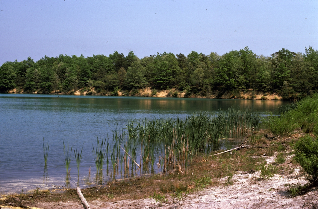
Figure 7. Lake Pam
Nudism has been a persistent aspect of Jersey life, with a fairly long history. Even today, nude beaches exist in New Jersey. Two nudist camps were established in the 1930s—Sky Farm in Bernards, Somerset County, established in 1932, and, more to the point, Sunshine Park, established along the Great Egg Harbor River in Mays Landing, in 1936.16 These were established for non-salacious purposes and part of a larger international cultural movement. Sunshine Park was important nationally as the center of the National Sunbathing Association and because of its publication, The Nudist. The Mays Landing property was sold to a psychologist in 1965 and persisted for a few decades until health code violations forced it to close. It was subsequently burned down.17 Some members of the Stockton community were known to have frequented Sunshine Park in its latter days. One famous visitor was the photographer Diane Arbus who, in 1963, took a picture at Sunshine Park of a waitress wearing only a silver headband and a demi-apron. This photograph sold at Sotheby’s for $138,000 in 2008.18
Following this precedent for public nude bathing, scenic Lake Pam served as Stockton’s nude beach for several years. The college was in a bit of a bind. It had determined that the campus would be open to use by the community, so, for a time, Lake Pam was an open secret. The lake’s existence as a nude beach led to some odd occurrences in the spray field. Couples seeking more intimate experiences would find their way to the spray field and recline on its soft lush grasses within its laterals. One would suppose that the sudden spray from unseen nozzles would bring an end to such activity. But even stranger was the situation where someone pitched a tent in a lateral and camped out. One can only wonder what the camper thought when it seemed to rain every forty-five minutes.
Eventually the word got out and a reporter came to interview the college president, Vera King Farris, about nude bathing at Lake Pam. In a flash of comedic brilliance, the president when asked about nude bathing replied, “I guess I’ll have to lose twenty pounds.” But the situation got to be too much of a nuisance. Local high school students would hold picnics involving alcoholic beverages and rowdy behavior. A story has it that one such visitor was seriously injured jumping from a rope swing while drunk. That put an end to all the frolicking, nude or not. No Trespassing signs were soon posted and the area was patrolled frequently by campus police, who drove away everyone including the nude bathers.
Finally, the creation of the grassy laterals drew other kinds of pests. These clearings, with their water-softened vegetation, drew large numbers of deer, rabbits and mice. Along with them, ticks and chiggers increased in number within these grassy habitats. So though it may have looked serenely sylvan, dangers lurked in the spray field.
Conclusions
The spray irrigation of effluent into the relatively sterile and dry Pine Barrens woodlands was potentially a good idea. The vegetation could certainly use the extra water and nutrients. The concept matched the college’s emphasis as an “Environmental College.” But the Stockton spray field was not a good test of this idea. The college could not open without sewage disposal, and they did not want to spend large sums on the field since it was only temporary, or so they thought. The people who could have ensured that the spray field was built properly were not on site during its construction. Their presence could have avoided the many errors that occurred during its construction. The field was too small, its laterals too wide, its situation at too low an elevation, and its “living filter” largely removed. Its effluent spray dosage exceeded the treatment plant design, and the field’s expansion was inadequate. Moreover, it lacked effluent storage for winter and storm conditions. The fact that the county sewer system took ten years to get to Stockton exacerbated the problem.
Nevertheless, the spray field provided valuable research at a time when little was known about the environmental impact of spray fields. This led to many student and faculty research experiences including talks at professional meetings, conferences on and off campus, and even publications. The problems encountered by the effluent spray field actually provided much vital information on what could go wrong. But to most of the Stockton community, the spray field was just a site on the road to the delights of Lake Pam.
Endnotes
(Most documents available in the University Archives, Bjork Library)
1 Minutes of the Stockton Board of Trustees, 1969. Stockton State College Prospectus, 1971–72 (1970).
2 Richard Schwartz, Working Paper #2. Campus Planning Seminar Retreat, March 4, 1970.
3 Letter from F. H. Lindquist, Jackson & Moreland to W. W. Cunningham, Geddes, Brecher, Quails, and Cunningham, January 8, 1971. “Stockton College Domestic Wastewater Treatment System.”
4 Letter from Thomas Boyd, Director of Campus Planning, Stockton State College to Joseph S. Mason, Atlantic County Mosquito Extermination Commission, April 30, 1974. “Sewerage Treatment Plant Spray Filed, Stockton State College.”
5 Faculty who took part in the study included Sandra Bierbrauer, Richard Colby, Arnold Cowmeadow, Carl Dury, Claude Epstein, John Griffiths, Benjamin Richards, Italo Russo and Gary Sawhill. Students who took part in the study included Michael Boyle, Gail Cibatoni, Gary Friedman, Jay Hallas, Bruce Hammell, Lynn Hiering, Teresa Hines, Nancy Lohrmann, James Marchione, Richard Marcley, Joseph Maher, Richard McGahey, Michael Melnick, Mark Newcomb, Thomas Pogranicy, Mitchell Press, Barton Presti, Ralph Putiri, Mark Raybould, Curtis Read, Thomas Rohlfing, Glen Sawhill, Robert Severson, John Shissler, John Sica, Charles Sinesi, Mark Stullenburger, Stanley Tarabar, Henry Tustin, John Van Epps, Jeffrey Weisneburger, Richard Westergaard and Jeffrey Wohlmuth. The “Stockton Stories” team welcomes stories from any of the faculty and, especially, students who took part in this study. We would like first-hand accounts by the Spray Field Spigots.
6 Richard Schwartz, Working Paper #2. Campus Planning Seminar Retreat, March 4, 1970.
7 Letter from Jack McCormick & Associates to Geddes, Brecher, Quails, & Cunningham, June 21, 1970, “Revision of estimates of effluent volume and land requirement for disposal of effluent. Addendum to report of June 15, 1970, Sewage Treatment and effluent disposal of Richard Stockton State College, Galloway Township, Atlantic County, New Jersey.”
8 Letter from F. H. Lindquist, Jackson & Moreland to W. W. Cunningham, Geddes, Brecher, Quails, and Cunningham, January 8, 1971, “Stockton College Domestic Wastewater Treatment System.”
9 Letter from Jack McCormick & Associates to Geddes, Brecher, Quails, & Cunningham, June 15, 1970, “Sewage Treatment and effluent disposal at Richard Stockton State College, Galloway Township, Atlantic County, New Jersey.”
10 Letter from Thomas Boyd, Director of Campus Planning, Stockton State College to Joseph S. Mason, Atlantic County Mosquito Extermination Commission, April 30, 1974. “Sewerage Treatment Plant Spray Filed, Stockton State College.”
11 Richard Schwartz, Working Paper #2. Campus Planning Seminar Retreat, March 4, 1970. Letter from F. H. Lindquist, Jackson & Moreland to W. W. Cunningham, Geddes, Brecher, Quails, and Cunningham, January 8, 1971. “Stockton College Domestic Wastewater Treatment System.”
12 Letter from Silas Little, U.S. Forest Service (USDA) to Dr. Dan Moury, Stockton State College, April 20, 1972, “Cooperative Agreement between U.S. Forest Service and the Division of Natural Science & Mathematics.”
13 C. M. Epstein & G. Sawhill, “Changes in the Ground Cover of a New Jersey Pine Barrens Woodland from Installing & Operating Spray Irrigation of Sewage Effluent,” Bulletin of the New Jersey Academy of Science 22, 1 (1977): 6–11.
15 Gary S. Sawhill, The Effect of the Spray Irrigation of Secondary Treated Effluent on the Vegetation, Soils, and Water Quality in a New Jersey Pine Barrens Habitat (New Brunswick, NJ: Rutgers University doctoral dissertation, 1977), 126–44.
16 Fred Ferretti, “Nudist Movement, Shedding Old Stigma, Nears its 50th Anniversary,” New York Times, June 12, 1977.
17 “New Jersey Nudist Camp Burns,” Firehouse, January 16, 2007. Viewed November, 2018, https://www.firehouse.com/photo-story/article/10566400/new-jersey-nudist-camp-burns.
18 “The Waitress at Sunshine Park,” Whitedeercafe, April 20, 2008. Viewed November, 2018, http://whitedeercafe.blogspot.com/2008/04/waitress-at-sunshine-park.html.