Hydrography

 and fish measuring capabilities (right).")


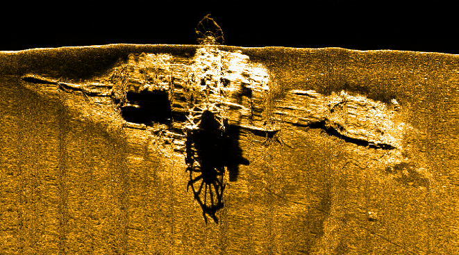
, showing an intact set of side paddlewheels.")
Side scan image of the Admiral DuPont (1865), showing an intact set of side paddlewheels.
The MFS provides the vessels and instrumentation for the hydrography program at Stockton. Instrumentation available for use by Stockton and visiting scientists includes; survey-grade (RTK) GPS and motion solutions, single beam and multibeam echo sounders, side scan sonar, magnetometer, mobile LiDAR, inspection-class Remotely Operated Vehicle, and aerial drones. Additional instrumentation is available through the oceanography program.
Professional staff at the MFS maintain and operate this instrumentation and support survey projects for the educational and research programs. The R/V Petrel offers a multi-purpose survey platform capable of operating several sensors simultaneously and fitting the needs of river, inlet and near-coastal survey projects requiring up to 18 hour support. Smaller vessels for shallow-water survey work are also available. All survey vessels are equipped with on-board RTK GPS systems and are directly operated by knowledgeable marine surveyors that can assist faculty and visiting groups with sensor integrations and troubleshooting.
Current research projects include:
- ROV monitoring of artificial reef ecology and biological succession
- Marine debris survey programs
- Sonar training programs for commercial fisherman and recovery teams
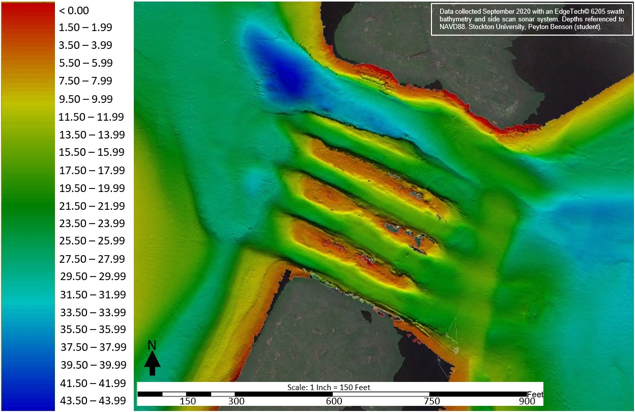
- Mullica River bathymetry and bottom classification mapping
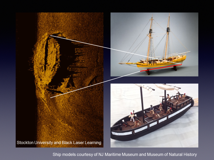
- Shipwrecks of the Mullica River
- Request data
Recent collaborative research support has included;
- Geophysical mapping of the Little Egg Inlet area, USGS (Barnhardt PI), 2018
- Offshore sand resources and geological mapping, Long Beach Island, NJGWS (Gagliano PI), 2019
- RJ Walker mapping project, NOAA (Delgado PI), 2015
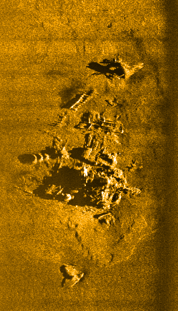
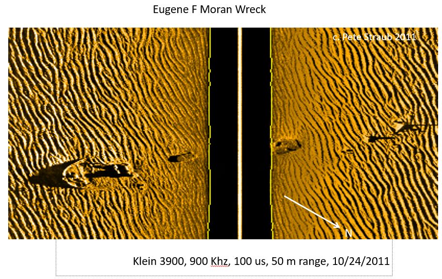
Bathymetry and side scan sonar image library;
- Blood Ditch bathymetry
- Mullica River Chestnut Neck area (Benson)
- Jessie C, Little Egg Artifical Reef
- Admiral Dupont
- RJ Walker (25 Dollar wreck)
- Phoel wreck
- Eugen Moran
Current hydrography internships and job postings
For more information about current projects or to collaborate in our region on a related project requiring hydrographic or vessel support contact MFS@stockton.edu.
The program is a member of the Marine Technology Society and The Hydrographic Society of America and has placed numeorus students into the field of marine survey locally and abroad.
Marine Field Station picks for stuff to check out if you are interested in hydrography (updated randomly!)
- What is hydrography? https://oceanservice.noaa.gov/facts/hydrography.html
- NOAA Office of Coast Survey https://nauticalcharts.noaa.gov/learn/learn-about-hydrography.html
- Nautilus Live https://nautiluslive.org/about
- Understanding the ocean with water column data https://storymaps.arcgis.com/stories/e245977def474bdba60952f30576908f
- Indeed - how to become a hydrographer! https://www.indeed.com/career-advice/finding-a-job/how-to-become-hydrographic-surveyor
- Women in hydrography https://www.hydro-international.com/content/article/women-power-noaa-hydrography
- IHO - what is hydrography https://iho.int/en/what-is-hydrography
- Seabed 2030 https://seabed2030.org/
Hydrography-related news at Stockton
2023 - alums paths to hydrography careers
2021 artificial reef survey project
2021 NSF funds acquisition of an R2Sonic multibeam sonar
2018 revolutionary war shipwrecks discovered

